A Beacon of Hope: Smith Myers Artemis in Natural Disasters & Catastrophic Events
Biggleswade, UK — 28th September 2023 —
Author Ewan McDonald – Smith Myers Training Manager and former British Army Practitioner
In the face of natural disasters and catastrophes, time is of the essence. Lives hang in the balance, and a quick and effective response is the difference between life and death. Response time is arguably the most important factor in increasing survival in a disaster.
Recent extreme global natural disaster events such as wide-spread wildfires, devastating floods and powerful earthquakes, are all fast moving and dynamic situations where Search and Rescue teams need rapid and coordinated responses to rapidly evolving and complex situations. All of these events degrade, disrupt or destroy the most powerful communication systems we have, The Cellular Network.
This is where ARTEMIS emerges as a game-changer.
ARTEMIS not only helps locate survivors or victims by turning every mobile phone into a rescue beacon, but also facilitates crucial communications (cellular voice/SMS) that allows persons in distress to place emergency calls/SMS to ARTEMIS and facilitates the location and communication of rescue teams. In this blog post, we will explore how the Smith Myers ARTEMIS system serves as a beacon of hope in the darkest of times.
Locating Survivors or Victims
In the aftermath of a catastrophe, chaos often reigns supreme. Earthquakes, hurricanes, floods, wildfires and other natural disasters can leave people trapped beneath rubble or stranded in remote locations with no means to alert first responders to their location or predicament. Time is of the essence when it comes to locating survivors and victims. ARTEMIS, with its advanced technology, takes on this challenge with remarkable precision, allowing rescue teams to locate victims via their mobile phones and cellular devices, even when the existing mobile-phone infrastructure is destroyed.
Cutting-edge Sensor
ARTEMIS boasts a custom-designed, state-of-the-art Software Defined Radio architecture, and uses standards based cellular protocols (2G, 3G, 4G & 5G) which are able penetrate debris, smoke, snow and water to help identify potential signs of life. These capabilities enable rescue teams to quickly pinpoint the exact location of survivors, significantly reducing response times and increasing the chances of a successful rescue.
Real-time Data Analysis
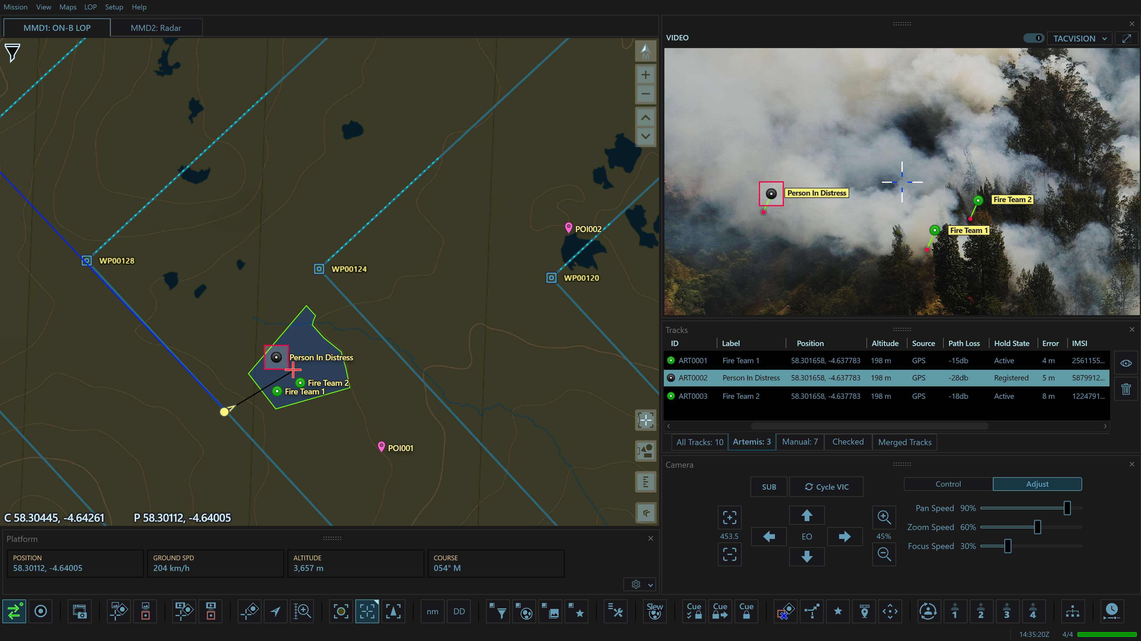
One of the ARTEMIS system’s standout features is its ability to provide real-time location data. This means that responders on the ground receive immediate updates on the situation, allowing them to adjust their approach as needed. This not only enhances the safety of survivors but also optimizes resource allocation during a crisis. ARTEMIS is already fully integrated with many first responders data dissemination tools, such as ATAK.

Courtesy of CarteNav
Communicating Instructions to Victims
Once survivors are located, the next critical step is ensuring their safety and providing guidance until rescue teams can reach them. ARTEMIS comes equipped with advanced communication tools that bridge the gap between survivors and responders, allowing the Rescue Operators to either voice call or SMS text the identified victim.
Two-way Communication
ARTEMIS also establishes a reliable two-way communication channel between survivors and emergency responders. This allows victims to receive instructions, share their condition and details of the situation around them, and even request specific assistance. In chaotic situations, this direct line of communication can be a lifeline allowing triage and critical prioritisation of victims for response teams.
Multilingual Support
ARTEMIS also offers multilingual support, recognizing that disasters can happen anywhere in the world, as underlined by the recent global events mentioned earlier. This ensures that language barriers do not hinder effective communication between responders and survivors.
Coordinating Rescue Teams
In large-scale catastrophe scenarios, multiple rescue teams and agencies often converge on the scene. Effective coordination is essential to avoid duplication of efforts and ensure a streamlined response. ARTEMIS also helps here by providing data to the central hub for this coordination.
Geospatial Mapping
ARTEMIS provides real-time geospatial mapping of mobile phones in the disaster area, complete with the locations of survivors, rescue teams, and critical resources. This data enables coordination teams to allocate resources strategically and make informed decisions. In addition to cellular devices, ARTEMIS can also receive and locate the transmissions from dedicated Emergency and Personal Locator Beacons (PLBs) which operate on different frequency bands from cellular using the same two antenna configuration.
Resource Allocation
By monitoring the movements of rescue teams and tracking their progress, the ARTEMIS system helps allocate resources efficiently. This prevents overcrowding in certain areas while ensuring that no survivors are left unattended.
Seamless Integration
Smith Myers designed the ARTEMIS system with interoperability in mind. It seamlessly integrates with existing emergency response technologies and can be easily customized to meet the specific needs of different agencies and disaster scenarios through our comprehensive Application Programming Interface (API).
In conclusion, the Smith Myers ARTEMIS system stands as a beacon of hope in catastrophe scenarios. Its ability to locate thousands of survivors or victims quickly and accurately, facilitate communication, and coordinate rescue teams is nothing short of revolutionary. By harnessing cutting-edge technology and focusing on real-time data analysis, ARTEMIS not only saves lives but also empowers emergency responders to work more efficiently and effectively. In an uncertain world, having the ARTEMIS system at our disposal gives us the confidence that even in the darkest times, there is a beacon of hope. Your own mobile phone.
